If you were to make a big Venn diagram with fans of transit
maps in one big bubble and followers of ancient history in another big bubble,
I’m not sure how big the intersecting space would be. But I’m in it!
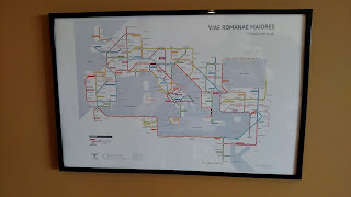
And gathering from the response to Sasha Trubetskoy’s transit-style map
of the main roads of the Roman Empire, there are quite a few of us!
You can see Sasha’s original posting here, with review in
CityLab here and Cameron Booth’s Transit Maps site (he gives it four stars –
not an easy achievement!) here. It’s
proven so popular that he’s added a more detailed “transit map” of Roman Road
in Britain (here).
Sasha notes that he had to “take some liberties” to make
this work, but partially that’s a matter of combining a diagrammatic layout
with a geographic one.
My only nerdy quibble: the sea connection between Brundisium
and Dyrrachium, a key link between
east and west and between Italy and the Via Egnatia, should be shorter.
And yes, you can order a copy.


